
Scalare il Kilimanjaro, la vetta più alta dell’Africa, è nel desiderio della maggior parte degli appassionati di avventura. L’arrampicata sul Kilimanjaro regala un’esperienza davvero unica mentre sali sulla vetta della montagna indipendente più alta del mondo.
Panoramica
Parti per un’avventura emozionante mentre conquisti il Monte Kilimanjaro, la vetta più alta dell’Africa e una delle montagne più iconiche del mondo. Questa maestosa spedizione offre una miscela esaltante di bellezza naturale, sfida fisica e immersione culturale. Preparati a mettere alla prova la tua resistenza e determinazione mentre sali attraverso diverse zone climatiche, che vanno dalle lussureggianti foreste pluviali agli aspri deserti alpini. Nel trekking lungo percorsi ben definiti, come i famosi sentieri Marangu o Machame, sarai guidato da alpinisti esperti che garantiranno la tua sicurezza e forniranno preziosi spunti sulla ricca storia e geologia della montagna.
Man mano che sali gradualmente i pendii, il paesaggio circostante si apre davanti ai tuoi occhi, rivelando panorami mozzafiato di ampie vallate, ghiacciai scintillanti e orizzonti lontani. Lasciati stupire dalle splendide albe e tramonti che dipingono il cielo con tonalità vivaci, creando momenti indimenticabili che rimarranno impressi nella tua memoria. Lungo il percorso incontrerai una varietà di flora e fauna, tra cui specie vegetali uniche come lobelie giganti e uccelli colorati che chiamano questo habitat montuoso la loro casa. Interagisci con le comunità locali, come il popolo Chagga, e approfondisci le loro tradizioni e il loro stile di vita, aggiungendo una dimensione culturale al tuo viaggio.

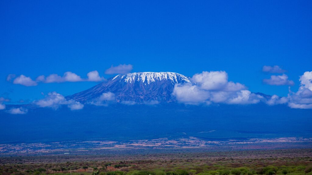
Durante la salita finale per raggiungere la vetta, Uhuru Peak, dovrai fare appello alla tua forza e resistenza. L’altitudine e le condizioni meteorologiche estreme metteranno alla prova i tuoi limiti fisici e mentali, ma il senso di realizzazione quando ti trovi in cima al punto più alto dell’Africa è incommensurabile. Goditi la gloria di questo risultato monumentale e ammira viste panoramiche che si estendono a perdita d’occhio. Scalare il Kilimanjaro non è solo una spedizione; è un’esperienza formativa che spinge oltre i tuoi limiti, favorisce la crescita personale e lascia un segno indelebile nella tua anima. Che tu sia un avventuriero esperto o uno scalatore alle prime armi, questa maestosa montagna promette un viaggio indimenticabile pieno di stupore, cameratismo e la soddisfazione di conquistare le vette più imponenti della natura.
percorsi per scalare il Kilimanjaro
Seleziona Percorso da visualizzare
5 giorni - Marangu Route - $ 1.500 a persona
La Marangu route, comunemente nota come Coca Cola route, è il più popolare perché può essere percorso in meno giorni e dispone di capanne permanenti per dormire nei campeggi. La salita per la vetta è ripida, parte da Kibo Hut e passa da Gilman's Point a Uhuru Peak. È un percorso più breve con una pendenza più ripida e meno tempo per l'acclimatazione e tende ad avere un tasso di successo in vetta inferiore. Questo è l'unico percorso in cui la via della salita e quella di discesa sono condivisi, creando così più traffico.
Durata: 5 o 6 giorni
Difficoltà: media
Scenario: buono
Traffico: alto
All'arrivo verrai accolto all'aeroporto e trasferito per il pernottamento presso un hotel di tua scelta. La tua guida ti incontrerà per il briefing, il controllo dell'attrezzatura. Eventuale attrezzatura mancante potrà essere noleggiata.
GIORNO 1: MARANGU GATE – MANDARA HUTS: 9 KM | 4-5 ORE | FORESTA PLUVIALE
Altitudine: da 1.830 m a 2.720 m
Partendo dal tuo hotel un veicolo ti porterà attraverso il villaggio di Marangu fino all'ingresso del Parco Nazionale del Kilimanjaro. Aspetteremo che i nostri permessi vengano rilasciati mentre osserviamo il trambusto delle operazioni degli equipaggi che si preparano per il viaggio. Goditi lo splendido scenario della foresta pluviale e i sentieri ventilati mentre la guida ti racconta la flora e la fauna locali. A queste quote più basse, il sentiero può essere fangoso e piuttosto scivoloso. Consigliamo vivamente ghette e bastoncini da trekking.
GIORNO 2: RIFUGIO MANDARA – RIFUGIO HOROMBO: 11 KM | 6-8 ORE | BRUGHIERA
Altitudine: da 2.720 m a 3.720 m
Dopo una buona notte di sonno e un'abbondante colazione, usciamo dalla foresta pluviale e proseguiamo su un sentiero in salita, attraverso la brughiera, alla ricerca di lobelie giganti e selvatiche. Si prosegue fino a brughiere aperte dove piccoli arbusti costituiscono la vegetazione principale. Ci fermiamo a metà strada per il pranzo e per godere delle splendide viste su Mawenzi. Arriviamo agli Horombo Huts nel tardo pomeriggio sotto lo spettacolare punto panoramico del Kibo Summit. Le temperature cominciano a scendere.
GIORNO 3: HOROMBO HUT - KIBO HUT: 10KM | 6-8 ORE | SEMI DESERTO
Altitudine: da 3.720 m a 4.703 m
Dopo colazione, proseguiremo attraverso la brughiera sempre più rarefatta che si trasforma in un paesaggio lunare non appena si entra nell'ampia sella che collega Mawenzi e Kibo. Mentre ci fermiamo per il pranzo, e più tardi, quando attraversi questa sella sorprendentemente grande, puoi ammirare la salita alla vetta, sopra a Kibo, che inizierai tra poche ore.
GIORNO 4: RIFUGIO KIBO – VETTA: 4KM SALITA | 5-7 ORE | GHIACCIAI, CIMA INNEVATA
VETTA - HOROMBO HUT: 14KM DISCESA | 5-6 ORE
Altitudine: da 4.703 m a 5.895 m
Discesa: fino a 3.720 m
L'eccitazione cresce quando la mattina arriva con la partenza anticipata tra mezzanotte e le 2 del mattino. Questa è la parte del trekking più impegnativa sia dal punto di vista mentale che fisico. Continuiamo il nostro cammino verso la vetta percorrendo il sentiero, cercando di rimanere al caldo e concentrati sullo straordinario senso di realizzazione che ci aspetta. Con un percorso a tornanti saliamo attraverso i pesanti ghiaioni ed eventualmente la neve, verso Gillman's Point sul bordo del cratere. Qui, durante il breve riposo, sarai ricompensato dalla magnifica alba che difficilmente potrai scordare. Gli escursionisti più veloci possono vedere l'alba dalla vetta. Da qui, durante la restante ora di salita verso l'Uhuru Peak, è probabile che incontrerai la neve lungo il percorso. Congratulazioni, un passo alla volta hai raggiunto Uhuru Peak, il punto più alto del Monte Kilimanjaro e dell'intero continente africano! Dopo foto, festeggiamenti e magari qualche lacrima di gioia ci prendiamo qualche istante per goderci questo incredibile risultato. Iniziamo la nostra ripida discesa fino al campo Mweka, fermandoci a Barafu per il pranzo e un breve riposo. Consigliamo vivamente bastoncini da trekking e ghette a causa dei terreni di ghiaia morbida e cenere vulcanica . Vi aspetta il meritato riposo per godervi la vostra ultima serata in montagna. Pernottamento al campo Mweka.
GIORNO 5: HOROMBO HUT – MARANGU GATE – MOSHI: 18KM |6-7 ORE | FORESTA PLUVIALE
Altitudine: da 3.720 m a 1.830 m
Dopo la colazione e una sincera cerimonia di apprezzamento e di legame con il tuo gruppo, è il momento di salutarci. Continuiamo la discesa fermandoci ai Rifugio Mandara per il pranzo. Ricordati di dare la mancia alle guide, ai cuochi e ai facchini, poiché li lascerai qui. Ritornati al Marangu Park Gate riceverai i certificati di vetta. Poiché il clima è drasticamente più caldo, il terreno può essere bagnato, fangoso e ripido e consigliamo vivamente ghette e bastoncini da trekking. Dal cancello, un veicolo ti incontrerà per riportarti al tuo hotel a Moshi (circa 45 minuti). Godetevi una doccia calda attesa da tempo, una cena e i festeggiamenti!!
6 giorni - Marangu Route - $1.650 a persona
La Marangu route, comunemente nota come Coca Cola route, è il più popolare perché può essere percorso in meno giorni e dispone di capanne permanenti per dormire nei campeggi. La salita per la vetta è ripida, parte da Kibo Hut e passa da Gilman's Point a Uhuru Peak. È un percorso più breve con una pendenza ripida e tende ad avere un tasso di successo in vetta inferiore. Per migliorare le possibilità il terzo giorno sarà dedicato all'acclimatamento. Questo è l'unico percorso in cui la via della salita e quella di discesa sono condivisi, creando così più traffico.
Durata: 5 o 6 giorni
Difficoltà: media
Scenario: buono
Traffico: alto
All'arrivo verrai accolto all'aeroporto e trasferito per il pernottamento presso un hotel di tua scelta. La tua guida ti incontrerà per il briefing, il controllo dell'attrezzatura. Eventuale attrezzatura mancante potrà essere noleggiata.
GIORNO 1: MARANGU GATE – MANDARA HUTS: 9 KM | 4-5 ORE | FORESTA PLUVIALE
Altitudine: da 1.830 m a 2.720 m
Partendo dal tuo hotel un veicolo ti porterà attraverso il villaggio di Marangu fino all'ingresso del Parco Nazionale del Kilimanjaro. Aspetteremo che i nostri permessi vengano rilasciati mentre osserviamo il trambusto delle operazioni degli equipaggi che si preparano per il viaggio. Goditi lo splendido scenario della foresta pluviale e i sentieri ventilati mentre la guida ti racconta la flora e la fauna locali. A queste quote più basse, il sentiero può essere fangoso e piuttosto scivoloso. Consigliamo vivamente ghette e bastoncini da trekking.
GIORNO 2: RIFUGIO MANDARA – RIFUGIO HOROMBO: 11 KM | 6-8 ORE | BRUGHIERA
Altitudine: da 2.720 m a 3.720 m
Dopo una buona notte di sonno e un'abbondante colazione, usciamo dalla foresta pluviale e proseguiamo su un sentiero in salita, attraverso la brughiera, alla ricerca di lobelie giganti e selvatiche. Si prosegue fino a brughiere aperte dove piccoli arbusti costituiscono la vegetazione principale. Ci fermiamo a metà strada per il pranzo e per godere delle splendide viste su Mawenzi. Arriviamo agli Horombo Huts nel tardo pomeriggio sotto lo spettacolare punto panoramico del Kibo Summit. Le temperature cominciano a scendere.
GIORNO 3: HOROMBO HUT
Puoi trascorrere un'intera giornata e una seconda notte a Horombo. In questo giorno potrete riposarvi nei rifugi o fare una passeggiata fino al campo base Mawenzi per poi tornare ai rifugi Horombo. Questo giorno in più ti aiuterà ad acclimatarti e ad approfondire la tua comprensione del clima e dell'altitudine della montagna. Il giorno seguente proseguirai per Kibo Huts per iniziare a mezzanotte la salita verso la vetta.
GIORNO 4: HOROMBO HUT - KIBO HUT: 10KM | 6-8 ORE | SEMI DESERTO
Altitudine: da 3.720 m a 4.703 m
Dopo colazione, proseguiremo attraverso la brughiera sempre più rarefatta che si trasforma in un paesaggio lunare non appena si entra nell'ampia sella che collega Mawenzi e Kibo. Mentre ci fermiamo per il pranzo, e più tardi, quando attraversi questa sella sorprendentemente grande, puoi ammirare la salita alla vetta, sopra a Kibo, che inizierai tra poche ore.
GIORNO 5: RIFUGIO KIBO – VETTA: 4KM SALITA | 5-7 ORE | GHIACCIAI, CIMA INNEVATA
VETTA - HOROMBO HUT: 14KM DISCESA | 5-6 ORE
Altitudine: da 4.703 m a 5.895 m
Discesa: fino a 3.720 m
L'eccitazione cresce quando la mattina arriva con la partenza anticipata tra mezzanotte e le 2 del mattino. Questa è la parte del trekking più impegnativa sia dal punto di vista mentale che fisico. Continuiamo il nostro cammino verso la vetta percorrendo il sentiero, cercando di rimanere al caldo e concentrati sullo straordinario senso di realizzazione che ci aspetta. Con un percorso a tornanti saliamo attraverso i pesanti ghiaioni ed eventualmente la neve, verso Gillman's Point sul bordo del cratere. Qui, durante il breve riposo, sarai ricompensato dalla magnifica alba che difficilmente potrai scordare. Gli escursionisti più veloci possono vedere l'alba dalla vetta. Da qui, durante la restante ora di salita verso l'Uhuru Peak, è probabile che incontrerai la neve lungo il percorso. Congratulazioni, un passo alla volta hai raggiunto Uhuru Peak, il punto più alto del Monte Kilimanjaro e dell'intero continente africano! Dopo foto, festeggiamenti e magari qualche lacrima di gioia ci prendiamo qualche istante per goderci questo incredibile risultato. Iniziamo la nostra ripida discesa fino al campo Mweka, fermandoci a Barafu per il pranzo e un breve riposo. Consigliamo vivamente bastoncini da trekking e ghette a causa dei terreni di ghiaia morbida e cenere vulcanica . Vi aspetta il meritato riposo per godervi la vostra ultima serata in montagna. Pernottamento al campo Mweka.
GIORNO 6: HOROMBO HUT – MARANGU GATE – MOSHI: 18KM |6-7 ORE | FORESTA PLUVIALE
Altitudine: da 3.720 m a 1.830 m
Dopo la colazione e una sincera cerimonia di apprezzamento e di legame con il tuo gruppo, è il momento di salutarci. Continuiamo la discesa fermandoci ai Rifugio Mandara per il pranzo. Ricordati di dare la mancia alle guide, ai cuochi e ai facchini, poiché li lascerai qui. Ritornati al Marangu Park Gate riceverai i certificati di vetta. Poiché il clima è drasticamente più caldo, il terreno può essere bagnato, fangoso e ripido e consigliamo vivamente ghette e bastoncini da trekking. Dal cancello, un veicolo ti incontrerà per riportarti al tuo hotel a Moshi (circa 45 minuti). Godetevi una doccia calda attesa da tempo, una cena e i festeggiamenti!!
6 giorni - Rongai Route - $ 1.650 a persona
Meno affollato a causa della sua posizione remota, il percorso offre agli escursionisti un'esperienza unica nella natura selvaggia dove è possibile vedere grandi animali selvatici come antilopi, elefanti e bufali. Poiché in genere c'è meno umidità su questo lato della montagna, è meno probabile che si verifichi la pioggia e questo consente una visione più limpida della vetta. Essendo più pianeggiante, l’altitudine delle prime notti è poca, quindi si consiglia di selezionare più giorni per l'acclimatazione. Il percorso Rongai è uno dei percorsi più facili sul Kilimangiaro. Rongai è l'unica via per avvicinarsi al Kilimanjaro da nord e la discesa avviene attraverso la Marangu Route. La salita alla vetta dal Kibo Hut è ripida e segue lo stesso percorso intrapreso dalla Marangu route che passa da Gilman's Point a Uhuru Peak. Esistono diverse varianti; quello descritto è un percorso più lungo che porta a Mawenzi Tarn.
Durata: 5 o 6 giorni
Difficoltà: media
Scenario: molto buono
Traffico: basso
All'arrivo verrai accolto all'aeroporto e trasferito per il pernottamento presso un hotel di tua scelta. La tua guida ti incontrerà per il briefing, il controllo dell'attrezzatura. Eventuale attrezzatura mancante potrà essere noleggiata.
GIORNO 1: NALE MURU GATE –SIMBA CAMP: 7 KM | 3-4 ORE | FORESTA PLUVIALE
Altitudine: da 1997 m a 2635 m
Partendo da Moshi, un viaggio di 4-5 ore ti porterà attraverso le piantagioni di caffè e il villaggio di Nale Muru fino all'ingresso del Parco Nazionale del Kilimanjaro. Aspetteremo pazientemente che i nostri permessi vengano rilasciati mentre osserviamo il trambusto delle operazioni mentre molti equipaggi si preparano per il viaggio. Aspetteremo che i nostri permessi vengano rilasciati mentre osserviamo il trambusto delle operazioni degli equipaggi che si preparano per il viaggio. Goditi lo splendido scenario della foresta pluviale e i sentieri ventilati mentre la guida ti racconta la flora e la fauna locali. Il campo Simba si trova vicino alla prima grotta al confine della zona della brughiera con viste spettacolari sulle pianure del Kenya.
GIORNO 2: SIMBA CAMP – SECOND CAVE CAMP: 5.8 KM | 5-6 ORE | BRUGHIERA
Altitudine: da 2.635 m a 3.487 m
Dopo una buona notte di sonno e un'abbondante colazione proseguiamo lungo il terreno brughiero su un sentiero in salita costante. Potrai osservare le viste fantastiche di Kibo e ammirare i ghiacciai sul bordo orientale del cratere. I piccoli arbusti della brughiera si fanno più radi man mano che si raggiunge la Seconda Grotta. Le temperature cominciano a scendere.
GIORNO 3: SECOND CAVE CAMP – THIRD CAVE CAMP: 3,3 KM | 3-4 ORE | SEMI DESERTO
Altitudine: da 2.635 m a 3.936 m
Dopo la colazione, preparato lo zaino, continuerai la tua salita costante, entrando nel terreno semidesertico. Questa giornata di escursione relativamente breve ti avvicina agli Easter ice fields, attirando continuamente la tua attenzione sulla loro bellezza. Presta attenzione al tuo corpo e mantieni la guida informata su eventuali segni di mal di montagna.
GIORNO 4: THIRD CAVE CAMP – KIBO HUT: 6,7 KM | 4-5 ORE | DESERTO ALPINO
Altitudine: da 3.936 m a 5.174 m
Si parte presto al mattino dalla zona semi-desertica dalla Third Cave e iniziamo il trekking nel terreno desertico alpino per il resto della salita. L'escursione di oggi ti porterà appena sotto la parete del cratere Kibo fino ai Kibo Huts. A questo punto ti unirai alla Marangu Route, che utilizzerai per raggiungere la vetta. Preparerai i tuoi vestiti e la tua attrezzatura (sostituirai le batterie per lampada frontale e fotocamera) prima di andare a letto entro le 19:00 e proverai a prenderti qualche ora di riposo prima del tuo tentativo in vetta.
GIORNO 5: RIFUGIO KIBO – VETTA: 4 KM SALITA | 5-7 ORE | GHIACCIAI, CIMA INNEVATA
VETTA - HOROMBO HUT: 14 KM DISCESA | 5-6 ORE
Altitudine: da 4.703 m a 5.895 m
Discesa: fino a 3.720 m
L'eccitazione cresce quando la mattina arriva con la partenza anticipata tra mezzanotte e le 2 del mattino. Questa è la parte del trekking più impegnativa sia dal punto di vista mentale che fisico. Continuiamo il nostro cammino verso la vetta percorrendo il sentiero, cercando di rimanere al caldo e concentrati sullo straordinario senso di realizzazione che ci aspetta. Con un percorso a tornanti saliamo attraverso i pesanti ghiaioni ed eventualmente la neve, verso Gillman's Point sul bordo del cratere. Qui, durante il breve riposo, sarai ricompensato dalla magnifica alba che difficilmente potrai scordare. Gli escursionisti più veloci possono vedere l'alba dalla vetta. Da qui, durante la restante ora di salita verso l'Uhuru Peak, è probabile che incontrerai la neve lungo il percorso. Congratulazioni, un passo alla volta hai raggiunto Uhuru Peak, il punto più alto del Monte Kilimanjaro e dell'intero continente africano! Dopo foto, festeggiamenti e magari qualche lacrima di gioia ci prendiamo qualche istante per goderci questo incredibile risultato. Iniziamo la nostra ripida discesa fino al campo Mweka, fermandoci a Barafu per il pranzo e un breve riposo. Consigliamo vivamente bastoncini da trekking e ghette a causa dei terreni di ghiaia morbida e cenere vulcanica . Vi aspetta il meritato riposo per godervi la vostra ultima serata in montagna. Pernottamento al campo Mweka.
GIORNO 6: HOROMBO HUT – MARANGU GATE – MOSHI: 18KM |6-7 ORE | FORESTA PLUVIALE
Altitudine: da 3.720 m a 1.830 m
Dopo la colazione e una sincera cerimonia di apprezzamento e di legame con il tuo gruppo, è il momento di salutarci. Continuiamo la discesa fermandoci ai Rifugio Mandara per il pranzo. Ricordati di dare la mancia alle guide, ai cuochi e ai facchini, poiché li lascerai qui. Ritornati al Marangu Park Gate riceverai i certificati di vetta. Poiché il clima è drasticamente più caldo, il terreno può essere bagnato, fangoso e ripido e consigliamo vivamente ghette e bastoncini da trekking. Dal cancello, un veicolo ti incontrerà per riportarti al tuo hotel a Moshi (circa 45 minuti). Godetevi una doccia calda attesa da tempo, una cena e i festeggiamenti!!
6 giorni - Umbwe Route: $ 1.600 a persona
Questo percorso è il più ripido con tragitti più brevi e diretti verso i ghiacciai meridionali Western Breach e Uhuru Peak. È probabilmente il percorso più panoramico fra i tracciati non tecnici del Kilimangiaro. Tuttavia è piuttosto faticoso, principalmente a causa della salita relativamente veloce a quote più elevate, ma le ricompense sono abbondanti. Itinerario molto ripido adatto ad escursionisti esperti.
Durata: 6 giorni
Difficoltà: molto alta
Scenario: molto buono
Traffico: molto basso
All'arrivo verrai accolto all'aeroporto e trasferito per il pernottamento presso un hotel di tua scelta. La tua guida ti incontrerà per il briefing, il controllo dell'attrezzatura. Eventuale attrezzatura mancante potrà essere noleggiata.
GIORNO 1: UMBWE GETE – UMBWE CAVE: 9,6 KM | 6-8 ORE | BRUGHIERA
Altitudine: da 1651 m a 2944 m
Altitudine guadagnata: 1293 m
Partenza da Moshi guidando verso l'ingresso del Parco Nazionale del Kilimanjaro. Aspetteremo che i nostri permessi vengano rilasciati mentre osserviamo il trambusto delle operazioni degli equipaggi che si preparano per il viaggio. Goditi lo splendido scenario della foresta pluviale e i sentieri ventilati mentre la guida ti racconta la flora e la fauna locali. A queste quote più basse il sentiero può essere fangoso e piuttosto scivoloso, consigliamo vivamente ghette e bastoncini da trekking. Il sentiero segue un crinale tra due profonde valli attraverso la fitta foresta montana. Il campo è arroccato tra enormi alberi e un fitto sottobosco.
GIORNO 2: UMBWE CAVE –BARRANCO CAMP: 4.75 KM | 4-6 ORE | BRUGHIERA
Altitudine: da 2944 m a 3986 m
Altitudine guadagnata: 1042 m
Dopo una buona notte di sonno e un'abbondante colazione, emergiamo dalla foresta pluviale e proseguiamo su un ripido sentiero in salita, lungo la cresta dell'Umbwe che scende leggermente fino al campo di Barranco situato nella valle. Le temperature cominciano a scendere.
GIORNO 3: BARRANCO CAMP –KARANGA CAMP: 5.2 KM | 3-4 ORE | DESERTO ALPINO
Altitudine: da 3.986 m piedi a 4.034 m
Altitudine guadagnata: 48 m
Dopo la colazione, proseguiamo su una ripida cresta lungo l'avventuroso Barranco Wall fino alla Valle Karanga e all'incrocio che si collega con il Mweka Trail. Questo è uno dei giorni più impressionanti in cui vedere la potenza, l'agilità e la forza del tuo gruppo sfrecciare su questo muro con quella che sembra tanta facilità. Pernottamento al campo Karanga.
GIORNO 4: KARANGA CAMP –BARAFU CAMP: 3,3KM | 3-4 ORE | DESERTO ALPINO
Altitudine: da 4.034 m a 4.662 m
Altitudine guadagnata: 628 m
Continuiamo verso il campo Barafu e, una volta raggiunto, abbiamo completato il circuito sud, che offre una varietà di viste mozzafiato sulla vetta da molte angolazioni diverse. Cena presto e riposo mentre ci prepariamo per la notte del summit. Pernottamento al campo Barafu.
GIORNO 5: BARAFU CAMP – VETTA: 4.86KM SALITA | 5-7 ORE | GHIACCIAI, CIMA INNEVATA
VETTA – MWEKA CAMP: 11.5KM DISCESA | 5-6 ORE
Altitudine: da 4.662 m a 5.895 m
Guadagno di altitudine: 1.233 m
Discesa: fino a 3.106 m
Altitudine persa: 2.789 m
L'eccitazione cresce quando la mattina arriva con la partenza anticipata tra mezzanotte e le 2 del mattino. Questa è la parte del trekking più impegnativa sia dal punto di vista mentale che fisico. Continuiamo il nostro cammino verso la vetta tra i ghiacciai Rebmann e Ratzel percorrendo il sentiero, cercando di rimanere al caldo e concentrati sullo straordinario senso di realizzazione che ci aspetta. Con un percorso a tornanti saliamo attraverso i pesanti ghiaioni ed eventualmente la neve, verso Stella Point sul bordo del cratere. Qui, durante il breve riposo, sarai ricompensato dalla magnifica alba che difficilmente potrai scordare. Gli escursionisti più veloci possono vedere l'alba dalla vetta. Da qui, durante la restante ora di salita verso l'Uhuru Peak, è probabile che incontrerai la neve lungo il percorso. Congratulazioni, un passo alla volta hai raggiunto Uhuru Peak, il punto più alto del Monte Kilimanjaro e dell'intero continente africano! Dopo foto, festeggiamenti e magari qualche lacrima di gioia ci prendiamo qualche istante per goderci questo incredibile risultato. Iniziamo la nostra ripida discesa fino al campo Mweka, fermandoci a Barafu per il pranzo e un breve riposo. Consigliamo vivamente bastoncini da trekking e ghette a causa dei terreni di ghiaia morbida e cenere vulcanica . Vi aspetta il meritato riposo per godervi la vostra ultima serata in montagna. Pernottamento al campo Mweka.
GIORNO 6: MWEKA CAMP –MWEKA GATE – MOSHI: 9,1 KM |3-4ORE | FORESTA PLUVIALE
Altitudine: da 3.106 m a 1.633 m
Altitudine persa: 1.473 m
Dopo la colazione e una sincera cerimonia di apprezzamento e di legame con il tuo gruppo, è il momento di salutarci. Continuiamo la discesa fino al Mweka Park Gate per ricevere i certificati di vetta. Poiché il clima è drasticamente più caldo, il terreno è bagnato, fangoso e ripido e consigliamo vivamente ghette e bastoncini da trekking. Dal cancello, un veicolo ti incontrerà al villaggio di Mweka per riportarti al tuo hotel a Moshi (circa 30 minuti). Godetevi una doccia calda attesa da tempo, una cena e i festeggiamenti!!
6 giorni - Machame Route: $ 1.750 a persona
La Machame Route, conosciuta anche come Whiskey Route, è uno dei percorsi più panoramici e consigliati del Kilimangiaro. I sentieri di questo popolare percorso attraversano magnifiche foreste per raggiungere una cresta che conduce alle zone di brughiera fino all'altopiano di Shira. Quindi attraversa i precipizi ghiacciati dei Southern Ice fields per unirsi alla Barafu Route fino alla vetta. Poiché può essere percorso per periodi più lunghi e la pendenza è più gestibile, ha un tasso di raggiungimento della vetta molto più elevato.
Durata: 6 o 7 giorni
Difficoltà: media
Scenario: eccellente
Traffico: alto
All'arrivo verrai accolto all'aeroporto e trasferito per il pernottamento presso un hotel di tua scelta. La tua guida ti incontrerà per il briefing, il controllo dell'attrezzatura. Eventuale attrezzatura mancante potrà essere noleggiata.
GIORNO 1: MACHAME GATE – MACHAME CAMP: 10,75 KM | 5-6 ORE | FORESTA PLUVIALE
Altitudine: da 1811 m a 3021 m
Altitudine guadagnata: 1210 m
Partenza da Moshi guidando attraverso il villaggio di Machame verso l'ingresso del Parco Nazionale del Kilimanjaro. Aspetteremo che i nostri permessi vengano rilasciati mentre osserviamo il trambusto delle operazioni degli equipaggi che si preparano per il viaggio. Goditi lo splendido scenario della foresta pluviale e i sentieri ventilati mentre la guida ti racconta la flora e la fauna locali. A queste quote più basse il sentiero può essere fangoso e piuttosto scivoloso, consigliamo vivamente ghette e bastoncini da trekking.
GIORNO 2: MACHAME CAMP – SHIRA CAMP: 5,3 KM | 4-5 ORE | BRUGHIERA
Altitudine: da 3.021 m a 3.839 m
Altitudine guadagnata: 818 m
Dopo una buona notte di sonno e un'abbondante colazione, usciamo dalla foresta pluviale e proseguiamo su un sentiero in salita, attraversando la valle lungo un ripido costone roccioso. Il percorso ora svolta a ovest lungo la gola del fiume fino ad arrivare a Shira Camp. Le temperature cominciano a scendere.
GIORNO 3: SHIRA CAMP – LAVA TOWER –BARRANCO CAMP: 10.75 KM | 5-6 ORE | SEMI DESERTO
Altitudine: da 3.839 m a 3.986 m
Altitudine guadagnata: 147 m
Anche se finisci la giornata alla stessa altitudine di quando hai iniziato, questa giornata è molto importante per l'acclimatazione. Dall'altopiano di Shira proseguiamo verso est su un crinale, superando il bivio verso il picco Kibo prima di proseguire, a sud-est, verso la Lava Tower, chiamata il “Dente di Squalo” (altitudine 4650 m). Poco dopo la torre arriviamo al secondo bivio che porta al ghiacciaio Arrow. Continuiamo quindi a scendere per pernottare al Barranco Camp.
GIORNO 4: BARRANCO CAMP –KARANGA CAMP –BARAFU CAMP: 8,5 KM | 6-8 ORE | DESERTO ALPINO
Altitudine: da 3.986 m a 4.034 m a 4.662 m
Altitudine guadagnata: 676 m
Dopo la colazione, proseguiamo su una ripida cresta fino all'avventuroso Barranco Wall fino alla Valle Karanga e all'incrocio che si collega con il Mweka Trail. Questo è uno dei giorni più impressionanti in cui vedere la potenza, l'agilità e la forza del tuo equipaggio sfrecciare su questo muro con quella che sembra tanta facilità. Continuiamo verso il campo Barafu e, una volta raggiunto, abbiamo completato il circuito sud, che offre una varietà di viste mozzafiato sulla vetta da molte angolazioni diverse. Cena presto e riposo mentre ci prepariamo per la notte del summit. Pernottamento al campo Barafu.
GIORNO 5: BARAFU CAMP – VETTA: 4.86KM SALITA | 5-7 ORE | GHIACCIAI, CIMA INNEVATA
VETTA – MWEKA CAMP: 11.5 KM DISCESA | 5-6 ORE
Altitudine: da 4.662 m a 5.895 m
Guadagno di altitudine: 1.233 m
Discesa: fino a 3.106 m
Altitudine persa: 2.789 m
L'eccitazione cresce quando la mattina arriva con la partenza anticipata tra mezzanotte e le 2 del mattino. Questa è la parte del trekking più impegnativa sia dal punto di vista mentale che fisico. Continuiamo il nostro cammino verso la vetta tra i ghiacciai Rebmann e Ratzel percorrendo il sentiero, cercando di rimanere al caldo e concentrati sullo straordinario senso di realizzazione che ci aspetta. Con un percorso a tornanti saliamo attraverso i pesanti ghiaioni ed eventualmente la neve, verso Stella Point sul bordo del cratere. Qui, durante il breve riposo, sarai ricompensato dalla magnifica alba che difficilmente potrai scordare. Gli escursionisti più veloci possono vedere l'alba dalla vetta. Da qui, durante la restante ora di salita verso l'Uhuru Peak, è probabile che incontrerai la neve lungo il percorso. Congratulazioni, un passo alla volta hai raggiunto Uhuru Peak, il punto più alto del Monte Kilimanjaro e dell'intero continente africano! Dopo foto, festeggiamenti e magari qualche lacrima di gioia ci prendiamo qualche istante per goderci questo incredibile risultato. Iniziamo la nostra ripida discesa fino al campo Mweka, fermandoci a Barafu per il pranzo e un breve riposo. Consigliamo vivamente bastoncini da trekking e ghette a causa dei terreni di ghiaia morbida e cenere vulcanica . Vi aspetta il meritato riposo per godervi la vostra ultima serata in montagna. Pernottamento al campo Mweka.
GIORNO 6: MWEKA CAMP –MWEKA GATE – MOSHI: 9,1 KM | 3-4ORE | FORESTA PLUVIALE
Altitudine: da 3.106 m a 1.633 m
Altitudine persa: 1.473 m
Dopo la colazione e una sincera cerimonia di apprezzamento e di legame con il tuo equipaggio, è il momento di salutarci. Continuiamo la discesa fino al Mweka Park Gate per ricevere i certificati di vetta. Poiché il clima è drasticamente più caldo, il terreno è bagnato, fangoso e ripido e consigliamo vivamente ghette e bastoncini da trekking. Dal cancello, un veicolo ti incontrerà al villaggio di Mweka per riportarti al tuo hotel a Moshi (circa 30 minuti). Godetevi una doccia calda attesa da tempo, una cena e i festeggiamenti!!
7 Days Rongai Route $ 1,750 per person
DAY 1: NALE MURU GATE – SIMBA CAMP: 7K /4.3MI | 3-4 HRS | RAINFORES
Elevation: 1997m/6552ft to 2635m/8645ft
Altitude gained: 638m
Departing from Moshi a 4-5 hour drive will take you through the coffee plantations and Village of Nale Muru to the Kilimanjaro National Park Gate. We will patiently wait for our permits to be issued while watching the hustle and bustle of operations as many crews prepare for the journey ahead Enjoy the beautiful wooded scenery, and windy trails while your guide tells you about the local flora and fauna and natural wildlife you are likely to see. Simba camp sits near the first cave at the edge of the moorland zone with spectacular views of the plains of Kenya.
DAY 2: SIMBA CAMP – SECOND CAVE CAMP: 5.8KM/3.6MI | 5-6HRS | MOORLAND
Elevation: 2635m/8645ft to 3487m/11,440ft
Altitude gained: 852m
After a good night sleep and a hearty breakfast we continue along moorland terrain on a consistent ascending path. You will catch some terrific views of Kibo and get your first glimpse of the ice fields on the Eastern crater rim. The small shrubs of the moorland became thinner as you approve the Second Cave. Temperatures begin to drop.
DAY 3: SECOND CAVE CAMP – KIKELEWA CAMP: 5.95KM/3.7MI | 2-3HRS | SEMI DESERT
Elevation: 3487m/11,440ft to 3675m/12057ft
Altitude gained: 188m
After breakfast and packing, you continue your stead ascent, entering into the semidesert terrain. This relatively short hiking day brings you closer to the Easter ice fields, continually drawing your attention to their beauty. Pay attention to your body and keep your guide informed of any signs of altitude sickness.
DAY 4: KIKELEWA CAMP- MAWENZI TARN: 3.75KM/2.3MI | 3-4HRS | SEMI DESERT
Elevation: 3487m/11440ft to 4302m/14114ft
Altitude gained: 627m
A short but steep climb up grassy slopes is rewarded by superb views. Leave the vegetation behind shortly before reaching the next camp at Mawenzi Tarn, spectacularly situated in a cirque directly beneath the towering spires of Mawenzi. The afternoon will be free to rest or explore the surrounding area as an aid to acclimatization. If you are spending an extra day on the mountain, you will camp for two nights here. You can hike up and around Mawenzi for your acclimatization hike.
DAY 5: MAWENZI TARN – KIBO HUT: 8.9KM /5MI | 4-5HRS | ALPINE DESERT
Elevation: 4302m/14,114ft to 4714m/15,466ft
Altitude gained: 412m
Cross the lunar desert of the ‘Saddle’ between Mawenzi and Kibo to reach Kibo campsite at the bottom of the Kibo crater wall. The remainder of the day is spent resting in preparation for the final ascent on Summit Night.
DAY 6: KIBO HUTS – SUMMIT: 4KM /2.5 MI UP | 5-7HRS | – HOROMBO HUTS: 15.75KM /9.8MI DOWN | 5-6HRS | GLACIERS, SNOW CAPPED SUMMIT
Elevation: 4302m/14,114ft to 5895m/19,341ft
Altitude gained: 721m
Descent to 3721m/12,208ft
Altitude lost: 2174m
Excitement is building as morning comes with an early start between midnight and 2 a.m. This is the most mentally and physically challenging portion of the trek. We continue our way to the summit between the Rebmann and Ratzel glaciers trying to stay warm and focused of the amazing sense of accomplishment that lies ahead. With a switchback motion in a northwesterly direction and ascend through heavy scree towards Stella Point on the crater rim. You will be rewarded with the most magnificent sunrise during your short rest here. Faster hikers may view the sunrise from the summit. From here on your remaining 1 hour ascent to Uhuru Peak, you are likely to encounter snow all the way. Congratulations, one step at a time you have now reached Uhuru Peak the highest point on Mount Kilimanjaro and the entire continent of Africa! After photos, celebrations and maybe a few tears of joy we take a few moments to enjoy this incredible accomplishment. We begin our steep descent down to Mweka Camp, stopping at Barafu for lunch and a very brief rest. We strongly recommend gaiters and trekking poles for uncooperative loose gravel and volcano ash terrain. Well-deserved rest awaits you to enjoy your last evening on the mountain. Overnight Mweka Camp.
DAY 7: HOROMBO HUTS – MARANGU GATE – MOSHI: 20KM/12.5MI |6-7HRS | RAINFOREST
Elevation: 3721m/12,208 to 1905m/6250ft
Altitude lost: 1816m
After breakfast and a heartfelt ceremony of appreciation and team bonding with your crew it’s time to say goodbye. We continue the descent down stopping at the Mandara Huts for lunch. Remember to tip your guides, cooks, and porters, since you will be leaving them here. You return back to the Marangu Park Gate and receive your summit certificates. As the weather is drastically warmer, the terrain is wet, muddy and steep and we highly recommend Gaiters and trekking poles. From the gate, a vehicle will meet you to drive you back to your hotel in Moshi (about 45 minutes). Enjoy a long overdue hot shower, dinner and celebrations!!
7 Days Lemosho Route $2,000 per person
As a newer route, it is more remote and arguably more beautiful, but a bit longer and slightly more expensive. It starts on the Western side of the mountain at the Londorossi Gate which is a further drive from town, and was introduced as an alternative to the Shira route. After beautiful forests and moorlands it crosses the Shira Plateau on day 3 to connect with the Machame Route at Lava Tower and down towards Barranco Valley via the Southern Circuit. You may be lucky enough to see buffalo, elephant and other game. Because this route can be done over a longer period of time for acclimatization, it has a higher success rate of summit.
- Duration: 7 or 8 days
- Difficulty: Medium
- Scenery: Excellent
- Traffic: Medium
DAY 1: LONDROSSI GATE – MTI MKUBWA CAMP: 4.8KM /3MI | 3-4 HRS | RAINFOREST
Elevation: 2389m/7838ft to 2785m/9137ft
Altitude gained: 396m
Departing from Moshi a 45-minute drive will take you through welcoming mountainside villages to the Kilimanjaro National Park Gate. We will patiently wait for our permits to be issued while watching the hustle and bustle of operations as many crews prepare for the journey ahead Enjoy the beautiful rainforest scenery and windy trails while your guide tells you about the local flora and fauna and natural wildlife. At these lower elevations, the trail can be muddy and quite slippery. We highly recommend gaiters and trekking poles here.
DAY 2: MTI MKUBWA CAMP – SHIRA I CAMP: 17KM/5MI | 6-8HRS | MOORLAND
Elevation: 2785m/9137ft to 3895m/12,779ft
Altitude gained: 1110m
After a good nights sleep and a hearty breakfast, we emerge from the rain forest and continue on an ascending path, we leave the forest behind now, the trail climbs steadily with wide views to reach the rim of the Shira Plateau. Temperatures begin to drop.
DAY 3: SHIRA 2 CAMP – LAVA TOWER – BARRANCO CAMP: 10.1KM/6MI | 5-7HRS | SEMI-DESERT
Elevation: 3895m/12,779ft to 3986m/13,077ft
Altitude gained: 91m
Although you end the day around the same elevation as when you began, this day is very important for acclimatization. From Shira Plateau we continue east up a ridge, passing the junction towards the Kibo peak before we then continue, South East towards the Lava Tower, called the “Shark’s Tooth” (elev. 4650m/15,250ft). Shortly after the tower, we come to a second junction, which leads to the Arrow Glacier. We then continue to descend to overnight at Barranco Camp.
DAY 4: BARRANCO CAMP – KARANGA CAMP: 5.2KM/3MI | 4-5HRS | ALPINE DESERT
Elevation: 3986m/13,077ft to 4034m/13,253ft
Altitude gained: 48m
After breakfast, we continue on a steep ridge up to the adventurous Barranco Wall to the Karanga Valley and the junction, which connects, with the Mweka Trail. This is one of the most impressive days to see the power, agility, and strength of your crew zip over this wall with what appears such ease. Overnight at Karanga Camp.
DAY 5: HIKE KARANGA CAMP – BARAFU CAMP: 3.3KM /2 MI | 4-5HRS | ALPINE DESERT
Elevation: 4034m/13,253ft to 4662m/15,295ft
Altitude gained: 628m
We continue up toward Barafu Camp, and once reached you have now completed the South Circuit, which offers a variety of breathtaking views of the summit from many different angles. An early dinner and rest as we prepare for summit night. Overnight at Barafu Camp.
DAY 6: BARAFU CAMP – SUMMIT: 5KM /3MI UP | 5-7HRS | – MWEKA CAMP: 11.5KM /8MI DOWN | 5-6HRS | GLACIERS, SNOW CAPPED SUMMIT
Elevation: 4662m/15,295ft to 5895m/19,341ft
Altitude gained: 1233m
Descent to 3090m/10,150ft
Altitude lost: 2789m
Excitement is building as morning comes with an early start between midnight and 2 a.m. This is the most mentally and physically challenging portion of the trek. We continue our way to the summit between the Rebmann and Ratzel glaciers trying to stay warm and focused on the amazing sense of accomplishment that lies ahead. With a switchback motion in a northwesterly direction and ascend through heavy scree towards Stella Point on the crater rim. You will be rewarded with the most magnificent sunrise during your short rest here. Faster hikers may view the sunrise from the summit. From here on your remaining 1 hour ascent to Uhuru Peak, you are likely to encounter snow all the way. Congratulations, one step at a time you have now reached Uhuru Peak the highest point on Mount Kilimanjaro and the entire continent of Africa! After photos, celebrations and maybe a few tears of joy we take a few moments to enjoy this incredible accomplishment. We begin our steep descent down to Mweka Camp, stopping at Barafu for lunch and a very brief rest. We strongly recommend gaiters and trekking poles for uncooperative loose gravel and volcano ash terrain. Well-deserved rest awaits you to enjoy your last evening on the mountain. Overnight Mweka Camp.
DAY 7: MWEKA CAMP – MWEKA GATE – MOSHI: 9.1KM/5.7MI |3-4HRS | RAINFOREST
Elevation: 3106m/10,190ft to 1633m/5358ft
Altitude lost: 1473m
After breakfast and a heartfelt ceremony of appreciation and team bonding with your crew, it’s time to say goodbye. We continue the descent down to the Mweka Park Gate to receive your summit certificates. As the weather is drastically warmer, the terrain is wet, muddy and steep and we highly recommend Gaiters and trekking poles. From the gate, a vehicle will meet you at Mweka village to drive you back to your hotel in Moshi (about 30 minutes). Enjoy a long overdue hot shower, dinner and celebrations!!
7 Days Machame Route $1,850 per person
DAY 1: MACHAME GATE – MACHAME CAMP: 10.75K /7MI | 5-6 HRS | RAINFOREST
Elevation: 1811m/5942ft to 3021m/9911ft
Altitude gained: 1210m
Departing from Moshi a 45-minute drive will take you through the Village of Machame to the Kilimanjaro National Park Gate. We will patiently wait for our permits to be issued while watching the hustle and bustle of operations as many crews prepare for the journey ahead Enjoy the beautiful rainforest scenery and windy trails while your guide tells you about the local flora and fauna and natural wildlife. At these lower elevations, the trail can be muddy and quite slippery. We highly recommend gaiters and trekking poles here.
DAY 2: MACHAME CAMP – SHIRA CAMP: 5.3KM/3MI | 4-5HRS | MOORLAND
Elevation: 3021m/9911ft to 3839m/12,595ft
Altitude gained: 818m
AAfter a good nights sleep and a hearty breakfast we emerge from the rain forest and continue on an ascending path, crossing the valley along a steep rocky ridge. The route now turns west onto a river gorge until we arrive at the Shira campsite. Temperatures begin to drop.
DAY 3: SHIRA CAMP – LAVA TOWER – BARRANCO CAMP: 10.75KM/6MI | 5-6HRS | SEMI-DESERT
Elevation: 3839m/12,595ft to 3986m/13,077ft
Altitude gained: 147m
Although you end the day around the same elevation as when you began, this day is very important for acclimatization. From Shira Plateau we continue east up a ridge, passing the junction towards the Kibo peak before we then continue, South East towards the Lava Tower, called the “Shark’s Tooth” (elev. 4650m/15,250ft). Shortly after the tower, we come to a second junction, which leads to the Arrow Glacier. We then continue to descend to overnight at Barranco Camp.
DAY 4: BARRANCO CAMP – KARANGA CAMP: 5.2KM/3MI | 3-4HRS | ALPINE DESERT
Elevation: 3986m/13,077ft to 4034m/13,235ft
Altitude gained: 48m
After breakfast, we continue on a steep ridge up to the adventurous Barranco Wall to the Karanga Valley and the junction, which connects, with the Mweka Trail. This is one of the most impressive days to see the power, agility, and strength of your crew zip over this wall with what appears such ease. Overnight at Karanga Camp.
DAY 5: HIKE KARANGA CAMP – BARAFU CAMP: 3.3KM /2 MI | 3-4HRS | ALPINE DESERT
Elevation: 4034m/13,235ft to 4662m/15,295ft
Altitude gained: 628m
We continue up toward Barafu Camp, and once reached you have now completed the South Circuit, which offers a variety of breathtaking views of the summit from many different angles. An early dinner and rest as we prepare for summit night. Overnight at Barafu Camp.
DAY 6: BARAFU CAMP – SUMMIT: 4.86KM /3MI UP | 5-7HRS | – MWEKA CAMP: 11.5KM /7.2MI DOWN | 5-6HRS | GLACIERS, SNOW CAPPED SUMMIT
Elevation: 4662m/15,295ft to 5895m/19,341ft
Altitude gained: 1233m
Descent to 3106m/10,190ft
Altitude lost: 2789m
Excitement is building as morning comes with an early start between midnight and 2 a.m. This is the most mentally and physically challenging portion of the trek. We continue our way to the summit between the Rebmann and Ratzel glaciers trying to stay warm and focused on the amazing sense of accomplishment that lies ahead. With a switchback motion in a northwesterly direction and ascend through heavy scree towards Stella Point on the crater rim. You will be rewarded with the most magnificent sunrise during your short rest here. Faster hikers may view the sunrise from the summit. From here on your remaining 1 hour ascent to Uhuru Peak, you are likely to encounter snow all the way. Congratulations, one step at a time you have now reached Uhuru Peak the highest point on Mount Kilimanjaro and the entire continent of Africa! After photos, celebrations and maybe a few tears of joy we take a few moments to enjoy this incredible accomplishment. We begin our steep descent down to Mweka Camp, stopping at Barafu for lunch and a very brief rest. We strongly recommend gaiters and trekking poles for uncooperative loose gravel and volcano ash terrain. Well-deserved rest awaits you to enjoy your last evening on the mountain. Overnight Mweka Camp.
DAY 7: MWEKA CAMP – MWEKA GATE – MOSHI: 9.1KM/6MI |3-4HRS | RAINFOREST
Elevation: 3106m/10,190ft to 1633m/5358ft
Altitude lost: 1473m
After breakfast and a heartfelt ceremony of appreciation and team bonding with your crew, it’s time to say goodbye. We continue the descent down to the Mweka Park Gate to receive your summit certificates. As the weather is drastically warmer, the terrain is wet, muddy and steep and we highly recommend Gaiters and trekking poles. From the gate, a vehicle will meet you at Mweka village to drive you back to your hotel in Moshi (about 30 minutes). Enjoy a long overdue hot shower, dinner and celebrations!!
INCLUDED IN TREKKING PACKAGE:
- Kilimanjaro trekking according to the itinerary
- Professional, English-speaking Wilderness First Responder & CPR certified Guide
- Proper Ration of Mountain crew (Cook & Porters)
- Pre and Post accommodations (2 nights Bed and Breakfast)
- Airport Transfers
- Meals according to the itinerary
- Drinking water and Full Board Meals
- All National Park & Camping Fees, Crew Permits and VAT
- Fair and Sustainable Salary Crew Wages
- Gate Transfers
- Complimentary Oxygen Cylinder
- Portable Private Toilet and Porter
- Quality Imported Equipments
EXCLUDED FROM TREKKING PACKAGE:
- Flights
- Visa fees
- Travel or Medical Insurance is required and you should ask for Recommendation
- Gamow Bag
- Medication
- Tips for porters and mountain crew (20% Industry Standard Recommended)
- Personal spending money for souvenirs etc.
- Energy food & beverages, alcoholic and soft drinks
- Personal hire gear such as trekking poles, sleeping bags, etc.
- Additional lodge nights for acclimatizing is $ 150 for one room bed breakfast
8 Days Lemosho Route $ 2,200 per Person
As a newer route, it is more remote and arguably more beautiful, but a bit longer and slightly more expensive. It starts on the Western side of the mountain at the Londorossi Gate which is a further drive from town, and was introduced as an alternative to the Shira route. After beautiful forests and moorlands it crosses the Shira Plateau on day 3 to connect with the Machame Route at Lava Tower and down towards Barranco Valley via the Southern Circuit. You may be lucky enough to see buffalo, elephant and other game. Because this route can be done over a longer period of time for acclimatization, it has a higher success rate of summit.
- Duration: 7 or 8 days
- Difficulty: Medium
- Scenery: Excellent
- Traffic: Medium
DAY 1: LONDROSSI GATE – MTI MKUBWA CAMP: 4.8KM /3MI | 3-4 HRS | RAINFOREST
Elevation: 2389m/7838ft to 2785m/9137ft
Altitude gained: 396m
Departing from Moshi a 45-minute drive will take you through welcoming mountainside villages to the Kilimanjaro National Park Gate. We will patiently wait for our permits to be issued while watching the hustle and bustle of operations as many crews prepare for the journey ahead Enjoy the beautiful rainforest scenery and windy trails while your guide tells you about the local flora and fauna and natural wildlife. At these lower elevations, the trail can be muddy and quite slippery. We highly recommend gaiters and trekking poles here.
DAY 2: MTI MKUBWA CAMP – SHIRA I CAMP: 7.9KM/5MI | 4-6HRS | MOORLAND
Elevation: 2785m/9137ft to 3504m/11,496ft
Altitude gained: 719m
After a good nights sleep and a hearty breakfast, we emerge from the rain forest and continue on an ascending path, we leave the forest behind now, the trail climbs steadily with wide views to reach the rim of the Shira Plateau. Temperatures begin to drop.
DAY 3: SHIRA I CAMP –SHIRA HUT: 6.9KM/4.3MI | 5-7HRS | MOORLAND
Elevation: 3504m/11,496ft to 3895m/12,779ft
Altitude gained: 391m
We explore the Shira plateau for a full day. It is a gentle walk east toward Kibo’s glaciered peak, across the plateau which leads to Shira 2 camp on moorland meadows by a stream. Then we continue to Moir Hut, a little-used site on the base of Lent Hills. A variety of walks are available on Lent Hills making this an excellent acclimatization opportunity. Shira is one of the highest plateaus on earth.
DAY 4: SHIRA HUT – LAVA TOWER – BARRANCO CAMP: 10.1KM/6.3MI | 4-6HRS | SEMI DESERT
Elevation: 3895m/12,779ft to 3986m/13,077ft
Altitude gained: 91m
Although you end the day around the same elevation as when you began, this day is very important for acclimatization. From Shira Plateau we continue east up a ridge, passing the junction towards the Kibo peak before we then continue, South East towards the Lava Tower, called the “Shark’s Tooth” (elev. 4650m/15,250ft). Shortly after the tower, we come to a second junction, which leads to the Arrow Glacier. We then continue to descend to overnight at Barranco Camp.
DAY 5: BARRANCO CAMP – KARANGA CAMP: 5.2KM/3MI | 4-5HRS | ALPINE DESERT
Elevation: 3986m/13,077ft to 4034m/13,235ft
Altitude gained: 48m
After breakfast, we continue on a steep ridge up to the adventurous Barranco Wall to the Karanga Valley and the junction, which connects, with the Mweka Trail. This is one of the most impressive days to see the power, agility, and strength of your crew zip over this wall with what appears such ease. Overnight at Karanga Camp.
DAY 6: HIKE KARANGA CAMP – BARAFU CAMP: 3.3KM /2 MI | 4-5HRS | ALPINE DESERT
Elevation: 4034m/13,235ft to 4662m/15,295ft
Altitude gained: 628m
We continue up toward Barafu Camp, and once reached you have now completed the South Circuit, which offers a variety of breathtaking views of the summit from many different angles. An early dinner and rest as we prepare for summit night. Overnight at Barafu Camp.
DAY 7: BARAFU CAMP – SUMMIT: 4.86KM /3MI UP | 5-7HRS | – MWEKA CAMP: 13KM /8MI DOWN | 5-6HRS | GLACIERS, SNOW CAPPED SUMMIT
Elevation: 4662m/15,295ft to 5895m/19,341ft
Altitude gained: 1233m
Descent to 3106m/10,190ft
Altitude lost: 2789m
Excitement is building as morning comes with an early start between midnight and 2 a.m. This is the most mentally and physically challenging portion of the trek. We continue our way to the summit between the Rebmann and Ratzel glaciers trying to stay warm and focused on the amazing sense of accomplishment that lies ahead. With a switchback motion in a northwesterly direction and ascend through heavy scree towards Stella Point on the crater rim. You will be rewarded with the most magnificent sunrise during your short rest here. Faster hikers may view the sunrise from the summit. From here on your remaining 1 hour ascent to Uhuru Peak, you are likely to encounter snow all the way. Congratulations, one step at a time you have now reached Uhuru Peak the highest point on Mount Kilimanjaro and the entire continent of Africa! After photos, celebrations and maybe a few tears of joy we take a few moments to enjoy this incredible accomplishment. We begin our steep descent down to Mweka Camp, stopping at Barafu for lunch and a very brief rest. We strongly recommend gaiters and trekking poles for uncooperative loose gravel and volcano ash terrain. Well-deserved rest awaits you to enjoy your last evening on the mountain. Overnight Mweka Camp.
DAY 8: MWEKA CAMP – MWEKA GATE – MOSHI: 9.1KM/6MI |3-4HRS | RAINFOREST
Elevation: 3106m/10,190ft to 1633m/5358ft
Altitude lost: 1473m
After breakfast and a heartfelt ceremony of appreciation and team bonding with your crew, it’s time to say goodbye. We continue the descent down to the Mweka Park Gate to receive your summit certificates. As the weather is drastically warmer, the terrain is wet, muddy and steep and we highly recommend Gaiters and trekking poles. From the gate, a vehicle will meet you at Mweka village to drive you back to your hotel in Moshi (about 30 minutes). Enjoy a long overdue hot shower, dinner and celebrations!!
INCLUSO NEL PACCHETTO:
- Trekking sul Kilimangiaro secondo l’itinerario scelto
- Guida professionista esperta di primo soccorso e certificata CPR (lingua inglese)
- Equipaggio di montagna (cuoco e facchini)
- Sistemazione pre e post trekking (2 notti)
- Trasferimenti aeroportuali
- Acqua potabile e pasti durante il trekking
- Costi per l’ingresso al parco nazionale, i rifugi, i permessi per l’equipaggio e l’IVA
- Salariali equi e sostenibili per l’equipaggio
- Trasferimento all’ingresso del parco e ritorno
- Bombola di ossigeno gratuita
- Commissioni per i trasferimenti con carta di credito
ESCLUSO DAL PACCHETTO:
- Voli
- Visto di ingresso in Tanzania
- È richiesta un’assicurazione di viaggio o medica
- Gamow Bag
- Farmaci
- Mance per i portatori e l’equipaggio di montagna
- Spese personali per souvenir, ecc…
- Alimenti e bevande energetiche, bevande alcoliche e analcoliche
- Noleggio di attrezzatura come bastoncini da trekking, sacchi a pelo, ecc.
- Notti aggiuntive in lodge per l’acclimatamento
- Notti aggiuntive in lodge in caso di discesa anticipata dalla montagna